

קובץ:Casey recreation limits 14598.tif

גודל התצוגה המקדימה הזאת מסוג JPG של קובץ ה־TIF הזה: 800 × 566 פיקסלים. רזולוציות אחרות: 320 × 226 פיקסלים | 640 × 453 פיקסלים | 1,024 × 725 פיקסלים | 1,280 × 906 פיקסלים | 2,560 × 1,812 פיקסלים | 3,507 × 2,482 פיקסלים.
לקובץ המקורי (3,507 × 2,482 פיקסלים, גודל הקובץ: 3.17 מ"ב, סוג MIME: image/tiff)
היסטוריית הקובץ
ניתן ללחוץ על תאריך/שעה כדי לראות את הקובץ כפי שנראה באותו זמן.
| תאריך/שעה | תמונה ממוזערת | ממדים | משתמש | הערה | |
|---|---|---|---|---|---|
| נוכחית | 16:30, 8 ביוני 2020 | 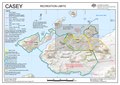 | 2,482 × 3,507 (3.17 מ"ב) | hewiki>De728631 | {{Information |Description={{en|Map of the {{w|Bailey Peninsula}}, Antarctica, with adjacent islands and the Australian {{w|Casey Station}}}} |Source=[https://data.aad.gov.au/aadc/mapcat/display_map.cfm?map_id=14598 Map 14598: Casey: Recreation Limits] |Date=2017-08 |Author=Australian Antarctic Division (Australia) |Permission={{Cc-by-3.0}}{{license review}} |other_versions= }} Category:Windmill Islands Category:Casey Station |
שימוש בקובץ
![]() אין במכלול דפים המשתמשים בקובץ זה.
אין במכלול דפים המשתמשים בקובץ זה.